
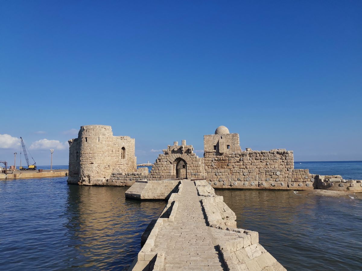
Saida houses an imposing sea castle, one of the few remaining crusader era monuments of the city.
It is one of a series of military strongholds that were erected in positions which enabled them to command anchorages and provide assured landing points for the armies sailing from Europe.
Purpose
Following the news of the imminent arrival of German emperor Frederick II to the Holy Land, the crusader armies residing in Acre set out towards Saida, where they located an isolated and strategic spot – the ancient Phoenician era port – to erect the castle and protect the coming ships.
Timeline
1227 – 1228 – Construction of the sea castle of Saida.
1291 – The castle was captured and destroyed by the Mamluks to prevent the Crusaders from re-establishing themselves. The Mamluks restored the castle at a later stage for their own use.
17th century – The castle was restored by Fakhr el-Dine Maan II.
1840 – The castle was severely damaged by the English maritime bombardments on Saida.
Structure
The stronghold experienced over the decades several restoration work due to destruction or to adapt to the military evolutions and needs.
The architectural plan of the castle is divided into two main sections:
Section 1 – The causeway
It is a jetty that links the promontory to the mainentrance of the castle, measuring about 80m.
At the top of the causeway, a massive platform can be noticed – it held a gate and a tower, connected by a bridge of four modern arches, the three piers of which remain standing.
The causeway is fitted with nozzles (triangular shape element) to protect the jetty and the harbor from the force of the waves. It is probably the only specimen of a fortified bridge from the Middle Ages still remaining in Lebanon and Syria.
Section 2 – The castle
The castle takes a semi-rectangular shape, measuring approximately 80m long and 50m wide, built from sandstone.
The main entrance of the castle is an arched gate ornamented with Crusader lapidary mark, topped by bas-reliefs of soldiers holding a weapon.
The castle has two towers that were once connected to each other by a defensive wall which foundations only remains.
The northern tower was the donjon of the castle. Measuring 27x21x8m, it is topped by an Ottoman era mosque, known as Masjid Bab Al Baher. Its eastern wall section is reinforced with columns taken from Roman or Byzantine era structures. On the northern side, the foundation of a semi-rounded structure can be seen, most likely a defensive tower.
The southern tower played a defensive role as it overlooks the entrance of the port, and measures approximately 25x20x10m. After the destruction of the castle by the Mamluks, they resotred the southern tower and inserted into its wall a marble slab that comemorate their works: بإسم الله الرحمن الرحيم أنشأ هذا الحصن (ب) السعيد المقر الكريم العالي المولوي الأمامي العا (ج) دلي العالمي … (د) جلبان الظاهري … (م) انصاره على نية الغزاة في سبيل الله تعالى في سنة إثنين (و) خمسين (وسبعمئة) …
The tower conserves today its arrow slits and the remnants of machicolated battlements.
The western façade of the castle completely collapsed following the English maritime bombardments.
*Scroll down to enjoy the pictures and to locate the site on the map.
*Subscribe at the bottom of this page to receive weekly articles and events.
Karim Sokhn
Tour Operator & Tour Guide
References:
دراسة في تاريخ مدينة صيدا في العصر الإسلامي، الدكتور عبد العزيز سالم
Les Chateaux desCroisds en Terre Sainte, Vol. III – La Defense du Comte de Tripoli et de laPrincipaute D’Antioch, 1973


